←
Satellite Image Classification
Galenbindunuwewa DS Division, Anuradhapura District
Project Overview
This project focuses on supervised satellite image classification
of the Galenbindunuwewa Divisional Secretariat Division using
Landsat imagery. The objective was to identify and map major
land use and land cover (LULC) classes to support land management,
environmental monitoring, and spatial planning.
Study Area
Galenbindunuwewa DS Division is located in the Anuradhapura District
of Sri Lanka’s North Central Province. The area is predominantly
agricultural, with extensive paddy cultivation, forest patches,
scattered settlements, water bodies, and wetlands that contribute
to regional ecological and hydrological systems.
Data Sources
- Landsat satellite imagery
- Administrative boundary of Galenbindunuwewa DS Division
- Reference sample points for accuracy assessment
Methodology
- Satellite image preprocessing
- Selection of training samples
- Supervised image classification
- Land use / land cover class labeling
- Accuracy assessment using confusion matrix
- Calculation of Producer’s Accuracy, User’s Accuracy, and Kappa coefficient
Satellite Image Classification Map
The classification map shows six major land cover classes including
water, forest, shrubland, developed areas, wetlands, and
planted/cultivated land. Cultivated land, mainly paddy fields,
dominates the landscape, while forest areas are concentrated
along the eastern boundary.
Land Cover Classes
- Water
- Developed Areas
- Forest
- Shrubland
- Planted / Cultivated Land
- Wetlands
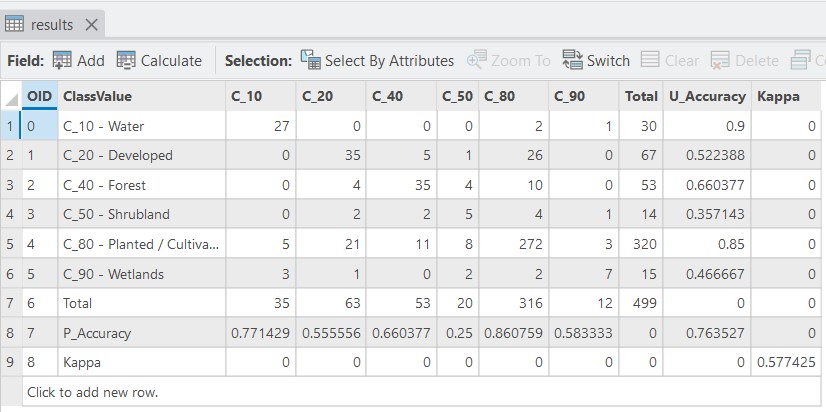
Accuracy Assessment
The accuracy assessment indicates an overall classification
accuracy of approximately 76.4% with a
Kappa coefficient of 0.577, showing moderate
agreement between classified data and reference samples.
Water and cultivated land classes achieved the highest
accuracy, while shrubland and wetlands showed lower reliability.
Key Observations
- Planted and cultivated land is the dominant land cover type
- Forest areas are concentrated along the eastern boundary
- Water bodies are distributed mainly in central and southern areas
- Developed areas are limited and sparsely distributed
- Wetlands occupy smaller but ecologically important areas
Tools & Skills
- ArcGIS Pro
- Supervised image classification
- Remote sensing data interpretation
- Accuracy assessment and validation
- Cartographic map layout design
Conclusion
This project strengthened practical skills in satellite image
classification, land cover interpretation, and accuracy evaluation.
The results provide valuable insights for land management and
environmental monitoring in the Galenbindunuwewa DS Division.