←
Spatial Correlation Analysis of Vegetation, Chlorophyll & Water Availability
Using Sentinel-2 Remote Sensing Indices
Project Overview
This project evaluates vegetation health, chlorophyll content, and water
availability in the Galenbindunuwewa Divisional Secretariat Division using
Sentinel-2 satellite imagery. NDVI, GCI, and LSWI indices were derived and
spatially analyzed to assess ecological conditions and inter-index relationships.
Study Area
The study area is the Galenbindunuwewa Divisional Secretariat (DS) Division
located in the Anuradhapura District of Sri Lanka. The region represents
a dry-zone environment with mixed land cover, including agricultural lands,
forests, water bodies, and settlements, making it suitable for vegetation
and water-related remote sensing analysis.
Data Sources
- Sentinel-2 Multispectral Imagery (Copernicus Open Access Hub)
- Bands: B3 (Green), B4 (Red), B8 (NIR), B11 (SWIR)
- Administrative boundary – Galenbindunuwewa DS Division
Methodology
- Preprocessing and cloud-free image selection
- NDVI, GCI, and LSWI calculation using raster algebra
- Thematic map generation and visual interpretation
- Random sampling (100 points) and value extraction
- Pearson correlation analysis and scatter plot generation
Remote Sensing Index Maps
Normalized Difference Vegetation Index (NDVI)

NDVI values range from -0.098 to 0.633, with higher values indicating
healthy and dense vegetation, mainly concentrated in agricultural
and forested regions.
Green Chlorophyll Index (GCI)

GCI values range from -0.22 to 2.71, reflecting chlorophyll concentration.
Areas with high GCI correspond closely with high NDVI zones.
Land Surface Water Index (LSWI)

LSWI values range from -0.609 to 0.432. Positive values highlight water
bodies and wetter zones, while negative values indicate drier areas.
Spatial Correlation Analysis
Vegetation Health vs Chlorophyll Content (NDVI & GCI)
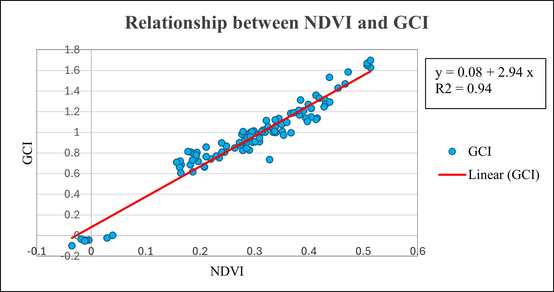
A strong positive linear relationship is observed (R² = 0.94),
indicating that vegetation health is strongly dependent on
chlorophyll content.
Vegetation Health vs Water Availability (NDVI & LSWI)
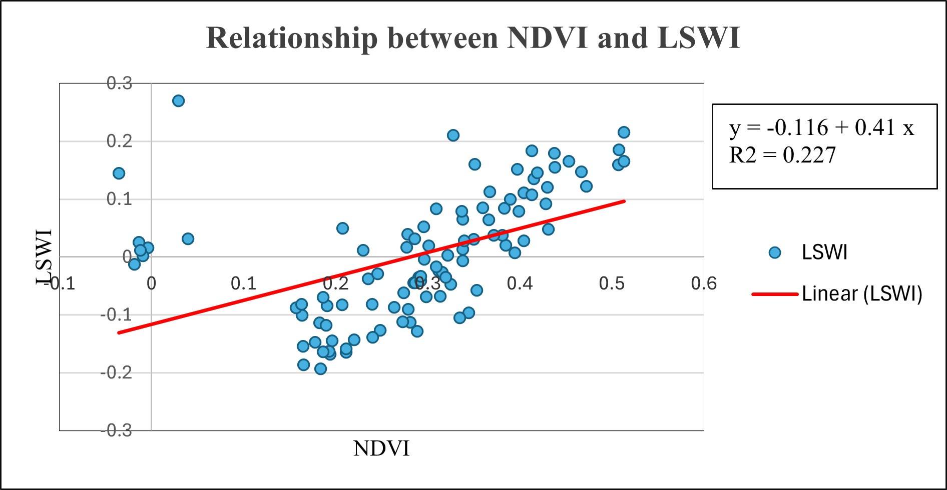
A moderate positive relationship (R² = 0.227) suggests that while
water availability supports vegetation health, other environmental
factors also play significant roles.
Key Findings
- NDVI and GCI show a very strong positive correlation
- LSWI exhibits spatial variability across the dry-zone landscape
- Vegetation health is influenced by moisture, soil, and land use
- Remote sensing indices effectively capture ecological stress patterns
Tools & Skills
- ArcGIS Pro
- Remote sensing index computation
- Spatial sampling and raster analysis
- Statistical correlation interpretation
- Cartographic map layout design
Conclusion
This study demonstrates the effectiveness of integrating NDVI, GCI,
and LSWI for environmental assessment in dry-zone regions. The results
provide valuable insights for sustainable land management, agricultural
monitoring, and resource planning.
